


Voting District 28, Wayne County, North Carolina
About
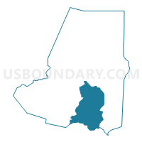
Outline

Summary
| Unique Area Identifier | 641808 |
| Name | Voting District 28 |
| County | Wayne County |
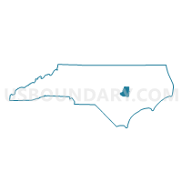
| State | North Carolina |
| Area (square miles) | 59.40 |
| Land Area (square miles) | 58.96 |
| Water Area (square miles) | 0.44 |
| % of Land Area | 99.26 |
| % of Water Area | 0.74 |
| Latitude of the Internal Point | 35.24821210 |
| Longtitude of the Internal Point | -77.97252490 |
Maps

Graphs
Select a template below for downloading or customizing gragh for Voting District 28, Wayne County, North Carolina


Neighbors
Neighoring Voting District (by Name) Neighboring Voting District on the Map
- Voting District 15, Wayne County, NC
- Voting District 17, Wayne County, NC
- Voting District 23, Wayne County, NC
- Voting District 26, Wayne County, NC
- Voting District 27, Wayne County, NC
- Voting District 30, Wayne County, NC
- Voting District CALY, Duplin County, NC
- Voting District WOLF, Duplin County, NC
Top 10 Neighboring County Subdivision (by Population) Neighboring County Subdivision on the Map
- Goldsboro township, Wayne County, NC (22,380)
- Brogden township, Wayne County, NC (21,881)
- New Hope township, Wayne County, NC (15,559)
- Indian Springs township, Wayne County, NC (7,790)
- Faison township, Duplin County, NC (4,489)
- Wolfscrape township, Duplin County, NC (3,267)
Top 10 Neighboring Place (by Population) Neighboring Place on the Map
- Goldsboro city, NC (36,437)
- Mount Olive town, NC (4,589)
- Elroy CDP, NC (3,869)
- Brogden CDP, NC (2,633)
Top 10 Neighboring Unified School District (by Population) Neighboring Unified School District on the Map
Top 10 Neighboring State Legislative District Lower Chamber (by Population) Neighboring State Legislative District Lower Chamber on the Map
- State House District 4, NC (82,523)
- State House District 11, NC (78,345)
- State House District 10, NC (77,125)
- State House District 21, NC (69,625)
Top 10 Neighboring State Legislative District Upper Chamber (by Population) Neighboring State Legislative District Upper Chamber on the Map
Top 10 Neighboring 111th Congressional District (by Population) Neighboring 111th Congressional District on the Map
Top 10 Neighboring Census Tract (by Population) Neighboring Census Tract on the Map
- Census Tract 901, Duplin County, NC (10,062)
- Census Tract 6.02, Wayne County, NC (8,980)
- Census Tract 9.02, Wayne County, NC (5,665)
- Census Tract 4.01, Wayne County, NC (5,253)
- Census Tract 6.01, Wayne County, NC (4,916)
- Census Tract 4.02, Wayne County, NC (4,448)
- Census Tract 7, Wayne County, NC (2,599)
- Census Tract 15, Wayne County, NC (2,587)
- Census Tract 8, Wayne County, NC (2,521)
- Census Tract 5, Wayne County, NC (2,325)
Top 10 Neighboring 5-Digit ZIP Code Tabulation Area (by Population) Neighboring 5-Digit ZIP Code Tabulation Area on the Map
- 27530, NC (40,117)
- 27534, NC (31,364)
- 28365, NC (17,144)
- 28333, NC (11,830)
- 28578, NC (6,363)
- 27531, NC (594)